Vietnam on Dutch maps
In 2023, it will be fifty years since Vietnam and the Netherlands established diplomatic relations. This will be commemorated in both countries. At the beginning of November, outgoing Prime Minister Mark Rutte visited Hanoi, the capital of Vietnam. On that occasion Leiden University Libraries will launch an online exhibition of maps of Vietnam, which will simultaneously be on display in Vietnam in a physical form.
Check the English version of the exhibition:
English version of the exhibitionCheck the Vietnamese version of the exhibition:
Vietnamese version of the exhibitionMaps of Vietnam
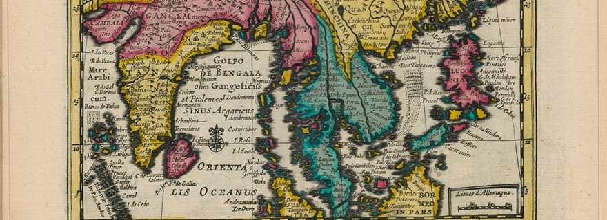
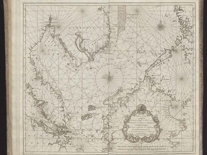
Leiden University Libraries possesses one of the most important map collections in the Netherlands. One of the focal points of the collection is the cartography of Asia, especially Indonesia and the areas where the Dutch East India Company was active. Of course, Vietnam is also represented in the map collection. The exhibition presents about thirty maps of Dutch manufacture, from the end of the sixteenth century to the present. Most of the maps show not only Vietnam but all countries around the South China Sea, with Laos, Cambodia, the Philippines and sometimes Indonesia. At the same time, the exhibition presents the whole spectrum of types of maps: single maps, atlases, sea charts and maps in books. The exhibition was created in close consultation with the embassy in Hanoi.

Diplomatic relations
To celebrate warm diplomatic relations between Vietnam and the Netherlands, Prime Minister Mark Rutte traveled to Hanoi with a trade delegation. There, he met Prime Minister Pham Minh Chinch and Communist Party (CPV) Secretary General Nguyen Phu Trong. The exhibition will open at the Diplomatic Academy of Vietnam, during a conference organized in cooperation with the Clingendael Institute. Rutte also spoke to a delegation of Dutch entrepreneurs active in Vietnam. The exhibition thus supports the diplomatic and economic mission.
Collections
The map of collections of the Leiden University Libraries excel in the large number of maps of Asia. These come largely from the collections of the Royal Tropical Institute (KIT, acquired 2013), the Royal Netherlands Institute of Southeast Asian and Caribbean Studies (KITLV, acquired 2014) and the private Steegh-Teunissen collection (acquired 2021). The acquisition of this collection almost doubled the number of maps in Leiden. Maps are not only used for exhibitions, they play an essential role in research and education in Leiden. The realization that maps are not only simply a representation of reality but usually give a (economically, ideologically) colored picture of reality is becoming increasingly widespread. Scientists therefore involve maps more often in their research. But of course maps are also appreciated for their aesthetic qualities. They can therefore be seen in numerous exhibitions.